Divergent: pulling apart
Plates separate, hot rock wells up and freezes into new sea floor.
Mid-Atlantic Ridge, East African Rift, Iceland


Home Tectonic Plates
52 plates
Drain the oceans and the seams of the planet appear. Earth’s shell is cracked into 52 plates that pull apart, dive under each other and grind past one another, a few centimetres a year.
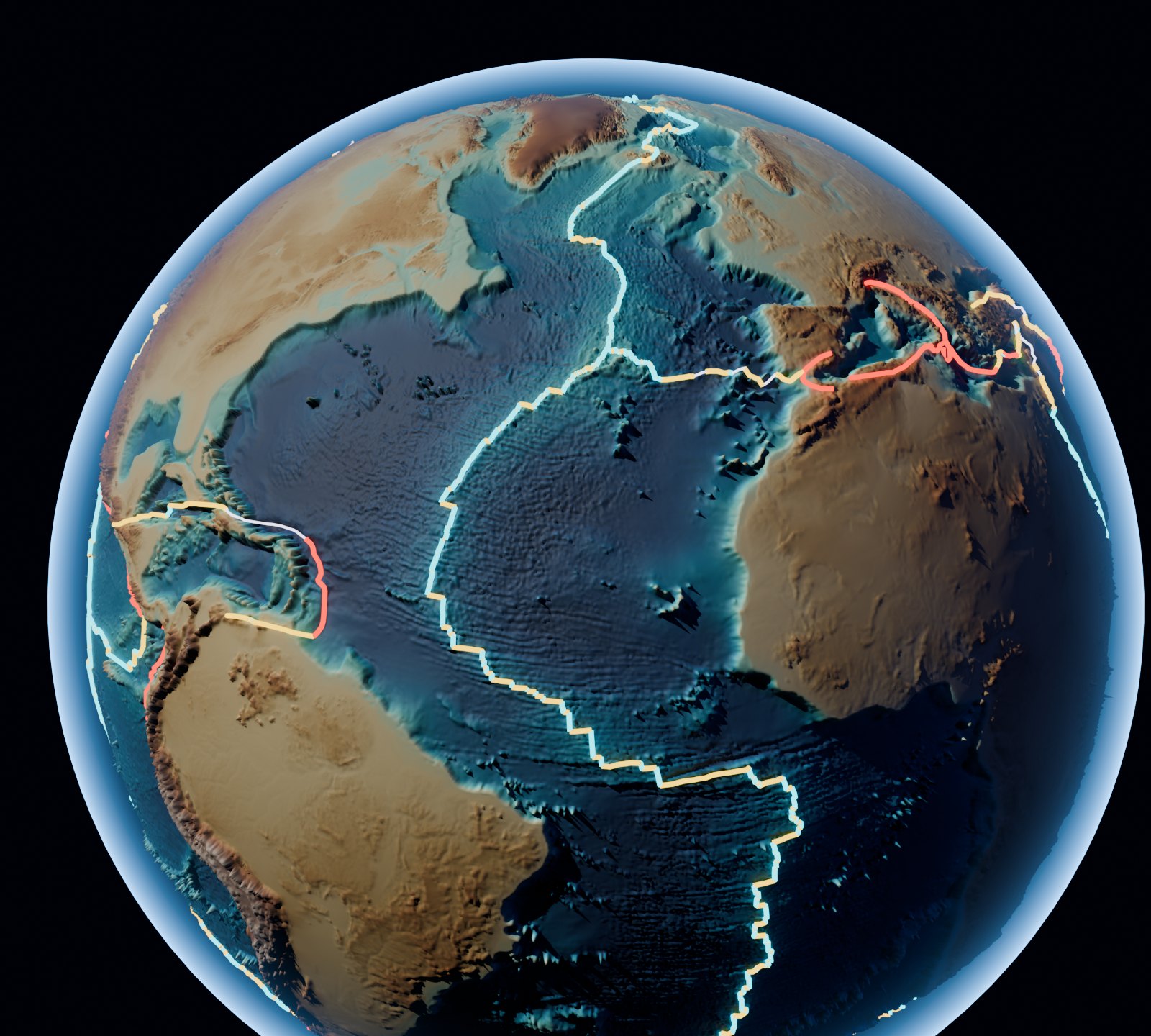
Plate explorer
Tap a plate to see how big it is, which plates it touches and what kind of edge it has. Switch boundary types on and off to see where each kind runs.
Equal Earth projection, so plate sizes compare fairly. Plates: Bird (2003) PB2002; boundary types: USGS.
How plates meet
Every boundary does one of three things. New crust is made at one, destroyed at another, and simply scraped past at the third.
Plates separate, hot rock wells up and freezes into new sea floor.
Mid-Atlantic Ridge, East African Rift, Iceland
Heavier ocean crust sinks into the mantle, building trenches, volcanoes and mountains.
Andes, Japan, the Himalaya, Mariana Trench
Plates scrape sideways. No crust is made or lost, but the fault stores up earthquakes.
San Andreas Fault, Alpine Fault, North Anatolian Fault
The giants
Seven plates carry 81% of the planet. The other 45 share what is left, and the smallest are a fraction of one tile.
All the seams
Lengths measured along the USGS boundary lines. “Other” covers diffuse zones and unclassified segments.
Data
| # | Plate | Area (M km²) | Share of Earth | Neighbours | Main edge |
|---|---|---|---|---|---|
| 1 | Pacific | 104.41 | 20.47% | 23 | Convergent |
| 2 | Antarctica | 58.47 | 11.46% | 10 | Divergent |
| 3 | Africa | 58.36 | 11.44% | 8 | Divergent |
| 4 | North America | 55.63 | 10.91% | 9 | Divergent |
| 5 | Eurasia | 48.73 | 9.55% | 11 | Transform |
| 6 | Australia | 45.91 | 9.00% | 18 | Divergent |
| 7 | South America | 41.77 | 8.19% | 9 | Transform |
| 8 | Somalia | 19.10 | 3.74% | 5 | Divergent |
| 9 | Nazca | 16.06 | 3.15% | 10 | Divergent |
| 10 | India | 12.40 | 2.43% | 5 | Convergent |
| 11 | Sunda | 8.87 | 1.74% | 9 | Convergent |
| 12 | Philippine Sea | 5.43 | 1.06% | 9 | Convergent |
| 13 | Amur | 5.31 | 1.04% | 5 | Divergent |
| 14 | Arabia | 4.90 | 0.96% | 5 | Divergent |
| 15 | Okhotsk | 3.05 | 0.60% | 5 | Other |
| 16 | Caribbean | 2.96 | 0.58% | 5 | Convergent |
| 17 | Cocos | 2.92 | 0.57% | 7 | Divergent |
| 18 | Yangtze | 2.20 | 0.43% | 5 | Other |
| 19 | Scotia | 1.70 | 0.33% | 4 | Transform |
| 20 | Caroline | 1.52 | 0.30% | 5 | Convergent |
| 21 | North Andes | 0.97 | 0.19% | 4 | Convergent |
| 22 | Altiplano | 0.83 | 0.16% | 2 | Convergent |
| 23 | Banda Sea | 0.69 | 0.14% | 5 | Other |
| 24 | New Hebrides | 0.64 | 0.13% | 4 | Divergent |
| 25 | Anatolia | 0.58 | 0.11% | 4 | Transform |
| 26 | Birds Head | 0.52 | 0.10% | 8 | Other |
| 27 | Burma | 0.51 | 0.10% | 4 | Convergent |
| 28 | Kermadec | 0.51 | 0.10% | 3 | Convergent |
| 29 | Woodlark | 0.45 | 0.09% | 8 | Convergent |
| 30 | Mariana | 0.42 | 0.08% | 2 | Convergent |
| 31 | Molucca Sea | 0.42 | 0.08% | 3 | Other |
| 32 | North Bismarck | 0.39 | 0.08% | 6 | Convergent |
| 33 | Timor | 0.35 | 0.07% | 3 | Convergent |
| 34 | Aegean Sea | 0.32 | 0.06% | 3 | Transform |
| 35 | Okinawa | 0.32 | 0.06% | 3 | Divergent |
| 36 | South Bismarck | 0.31 | 0.06% | 4 | Convergent |
| 37 | Panama | 0.27 | 0.05% | 4 | Convergent |
| 38 | Juan de Fuca | 0.26 | 0.05% | 2 | Divergent |
| 39 | Tonga | 0.25 | 0.05% | 4 | Convergent |
| 40 | Balmoral Reef | 0.19 | 0.04% | 4 | Transform |
| 41 | Sandwich | 0.18 | 0.04% | 3 | Convergent |
| 42 | Easter | 0.16 | 0.03% | 2 | Divergent |
| 43 | Conway Reef | 0.14 | 0.03% | 3 | Divergent |
| 44 | Solomon Sea | 0.13 | 0.03% | 4 | Convergent |
| 45 | Maoke | 0.12 | 0.02% | 3 | Convergent |
| 46 | Niuafo'ou | 0.12 | 0.02% | 4 | Divergent |
| 47 | Juan Fernandez | 0.10 | 0.02% | 3 | Divergent |
| 48 | Rivera | 0.10 | 0.02% | 3 | Transform |
| 49 | Shetland | 0.07 | 0.01% | 2 | Divergent |
| 50 | Futuna | 0.03 | 0.01% | 3 | Divergent |
| 51 | Galapagos | 0.01 | 0.00% | 3 | Divergent |
| 52 | Manus | 0.01 | 0.00% | 2 | Other |
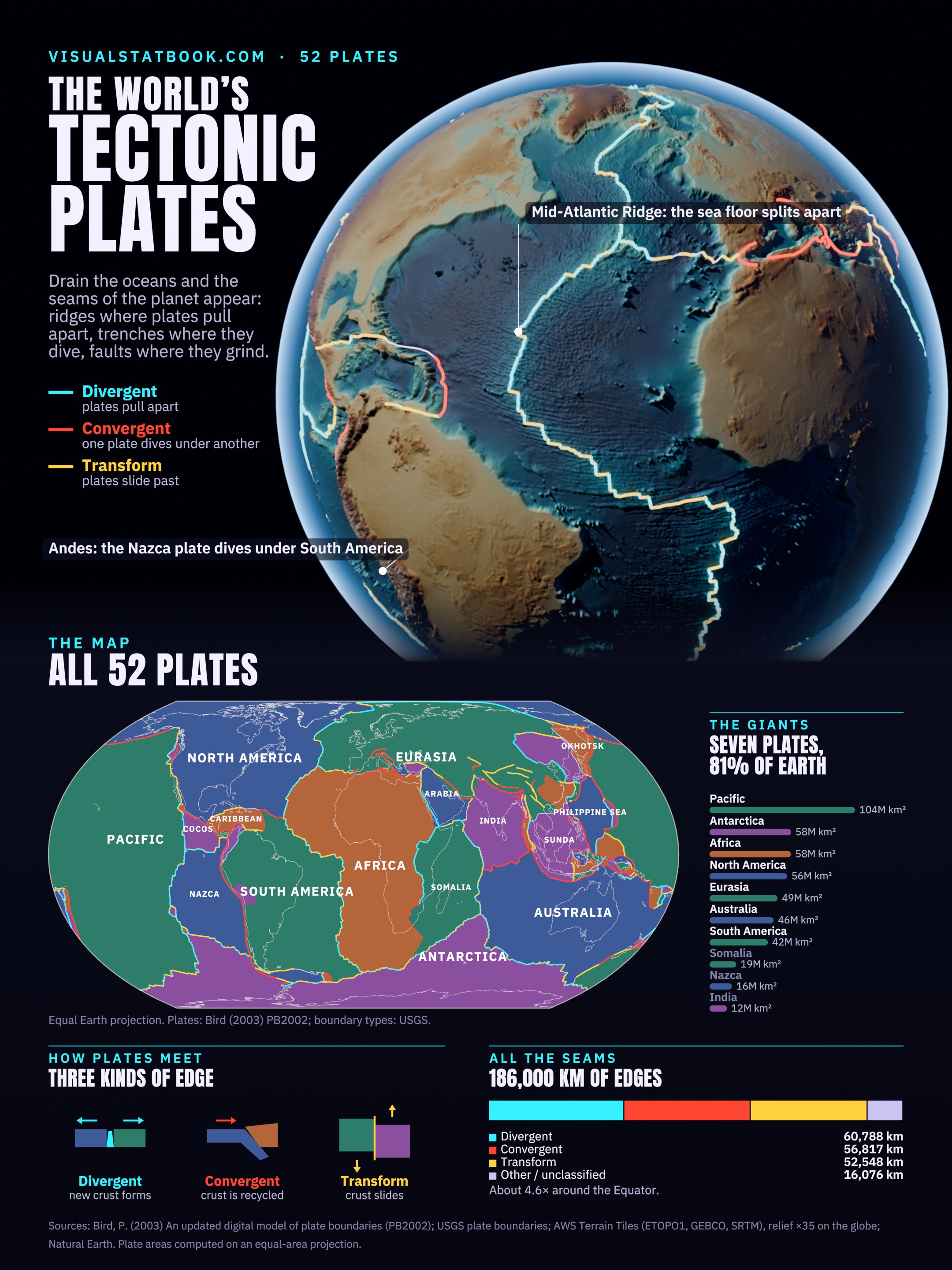
The poster
The globe, the full plate map, the giants and the three kinds of edge on one 2160 × 2880 poster.
Open the full-size posterQuestions
It depends on how finely they are split. Textbooks list 7 major plates and about 15 minor ones; the detailed PB2002 model used here has 52, including many microplates.
The Pacific plate: about 104 million km², or 20% of Earth’s surface, almost all of it ocean floor.
In PB2002 the smallest are the Manus and Galápagos microplates, each about 10,000 km², followed by Futuna.
Divergent (plates pull apart and make new crust), convergent (one plate sinks under another) and transform (plates slide past each other).
Typically 2 to 10 cm a year, about as fast as fingernails grow. The fastest spreading, on the East Pacific Rise, is around 15 cm a year.
Great Britain sits on the Eurasian plate. Most of the United States is on the North American plate, but coastal California west of the San Andreas Fault rides on the Pacific plate.
Sources: Bird, P. (2003), An updated digital model of plate boundaries, Geochemistry, Geophysics, Geosystems (PB2002); USGS plate boundary types; AWS Terrain Tiles (ETOPO1, GEBCO, SRTM) for the globe’s relief, exaggerated 35 times; Natural Earth coastlines. Plate areas are computed on an equal-area projection and scaled to Earth’s 510.07 million km². Per-plate boundary lengths are approximate.