Everest
8,849 m
5 kmvalley floor 4,994 m
- Countries
- Nepal / China
- First ascent
- 29 May 1953
- First in winter
- 17 February 1980
- Prominence
- 8,849 m
4 deaths per 100 summits (5,656 summits to 2012)


Home Tallest Mountains
The eight-thousanders
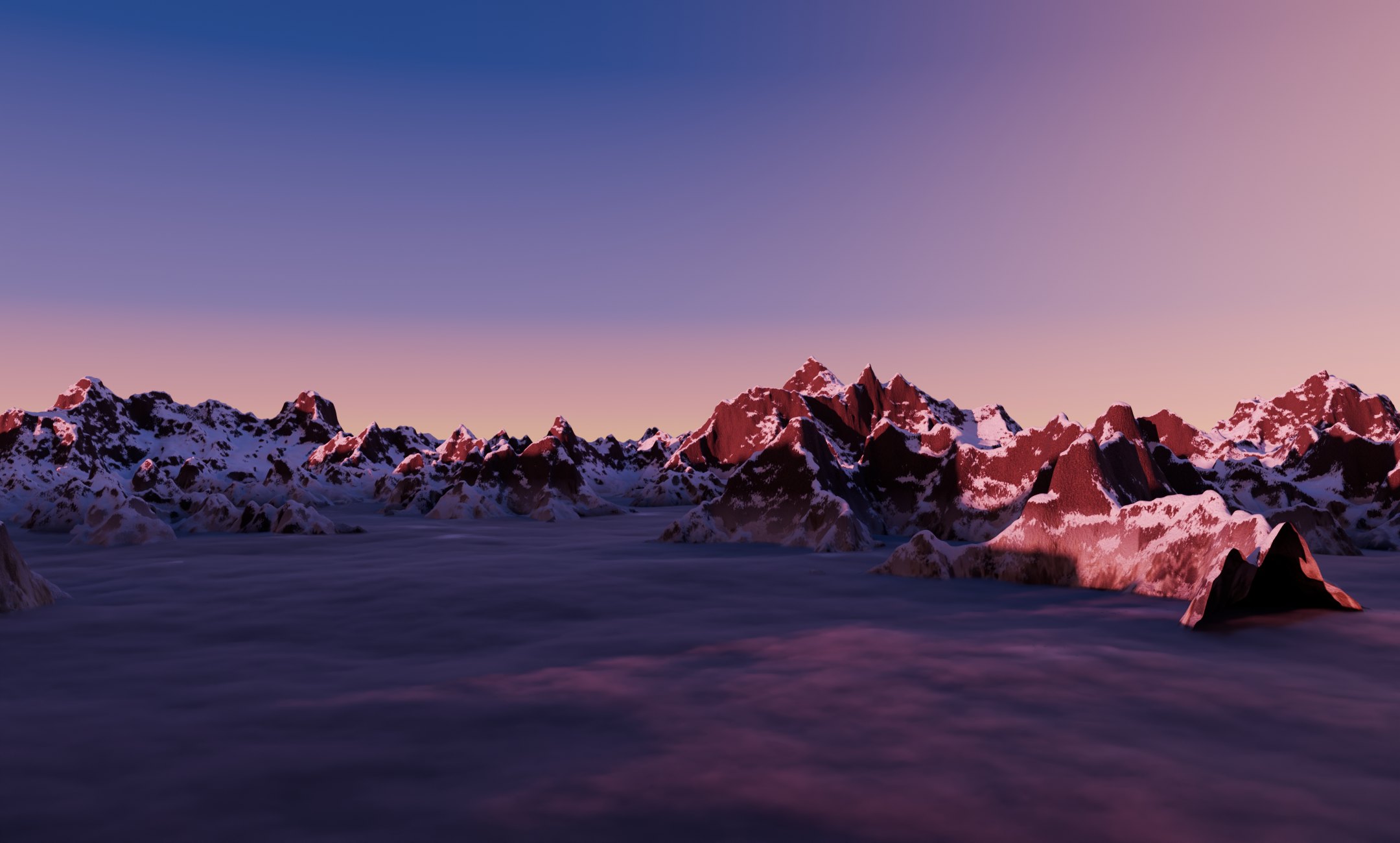
Only fourteen summits on Earth rise above 8,000 metres. Four of them stand here, within 45 km of each other.
Mahalangur Himal at sunset · Copernicus GLO-30 relief, heights ×1.5
The fourteen
Each card holds a 3D model of the mountain: the same 15 km square of real 30 m elevation and satellite colour, at true height and one shared scale, with a pin on the summit. Sort the deck to see who was climbed first, who held out longest in winter, and who has been deadliest.
5 kmvalley floor 4,994 m
4 deaths per 100 summits (5,656 summits to 2012)
5 kmvalley floor 4,836 m
12 deaths per 100 summits (800 summits to 2012)
5 kmvalley floor 4,700 m
16 deaths per 100 summits (243 summits to 2012)
5 kmvalley floor 4,537 m
3 deaths per 100 summits (461 summits to 2012)
5 kmvalley floor 4,085 m
9 deaths per 100 summits (361 summits to 2012)
5 kmvalley floor 4,947 m
1.4 deaths per 100 summits (3,138 summits to 2012)
5 kmvalley floor 2,827 m
15 deaths per 100 summits (448 summits to 2012)
5 kmvalley floor 3,412 m
10 deaths per 100 summits (661 summits to 2012)
5 kmvalley floor 3,284 m
20 deaths per 100 summits (335 summits to 2012)
5 kmvalley floor 2,431 m
32 deaths per 100 summits (191 summits to 2012)
5 kmvalley floor 4,548 m
9 deaths per 100 summits (334 summits to 2012)
5 kmvalley floor 4,457 m
5 deaths per 100 summits (404 summits to 2012)
5 kmvalley floor 4,420 m
2 deaths per 100 summits (930 summits to 2012)
5 kmvalley floor 4,765 m
8 deaths per 100 summits (302 summits to 2012)
Every block is cut at 2,000 m, so summits compare directly; no vertical stretch. A 30 m grid rounds off sharp tops, so the models sit 20 to 240 m below the surveyed heights. Rock bands on the cut sides are illustrative. Tap a model to find it on the map and the line-up.
One scale
All fourteen at the same scale, from sea level. Add familiar peaks and towers to see how far above everything else the eight-thousanders stand.
The air up there
Drag the slider from sea level to the summit of Everest. Air pressure, and with it the oxygen in every breath, falls by about a third every 3,000 metres.
The circles compare one breath at sea level (outline) with one breath at this height (filled), by the oxygen it holds. Standard-atmosphere values; real weather changes them.
Two ranges, one race
Ten peaks in the Himalaya, four in the Karakoram, about 1,300 km apart. Select a pin to find its card.
All fourteen were climbed between 1950 and 1964. Winter took far longer: K2 held out until 16 January 2021.
The data
| Rank | Mountain | Elevation | Range | Countries | First ascent | First winter ascent | Deaths per 100 summits* |
|---|---|---|---|---|---|---|---|
| 1 | Everest | 8,849 m | Himalaya | Nepal / China | 29 May 1953 | 17 February 1980 | 4 |
| 2 | K2 | 8,611 m | Karakoram | Pakistan / China | 31 July 1954 | 16 January 2021 | 12 |
| 3 | Kangchenjunga | 8,586 m | Himalaya | Nepal / India | 25 May 1955 | 11 January 1986 | 16 |
| 4 | Lhotse | 8,516 m | Himalaya | Nepal / China | 18 May 1956 | 31 December 1988 | 3 |
| 5 | Makalu | 8,485 m | Himalaya | Nepal / China | 15 May 1955 | 9 February 2009 | 9 |
| 6 | Cho Oyu | 8,188 m | Himalaya | Nepal / China | 19 October 1954 | 12 February 1985 | 1.4 |
| 7 | Dhaulagiri I | 8,167 m | Himalaya | Nepal | 13 May 1960 | 21 January 1985 | 15 |
| 8 | Manaslu | 8,163 m | Himalaya | Nepal | 9 May 1956 | 12 January 1984 | 10 |
| 9 | Nanga Parbat | 8,126 m | Himalaya | Pakistan | 3 July 1953 | 26 February 2016 | 20 |
| 10 | Annapurna I | 8,091 m | Himalaya | Nepal | 3 June 1950 | 3 February 1987 | 32 |
| 11 | Gasherbrum I | 8,080 m | Karakoram | Pakistan / China | 5 July 1958 | 9 March 2012 | 9 |
| 12 | Broad Peak | 8,051 m | Karakoram | Pakistan / China | 9 June 1957 | 5 March 2013 | 5 |
| 13 | Gasherbrum II | 8,035 m | Karakoram | Pakistan / China | 7 July 1956 | 2 February 2011 | 2 |
| 14 | Shishapangma | 8,027 m | Himalaya | China | 2 May 1964 | 14 January 2005 | 8 |
*1950 to March 2012, all deaths above base camp, per 100 summits (8000ers.com, E. Jurgalski). Elevations: published values; Everest uses the joint Nepal–China 2020 survey, 8,848.86 m.
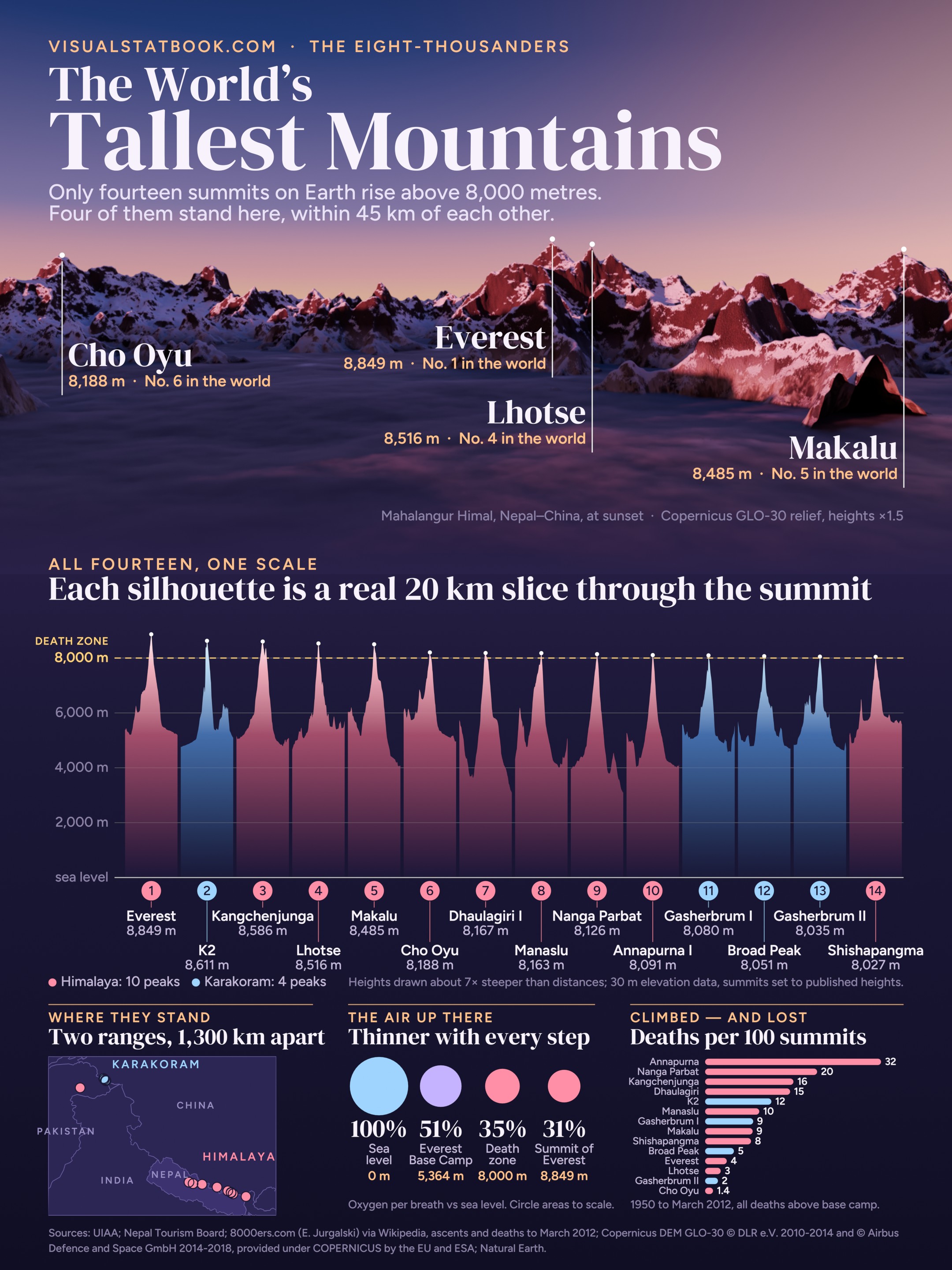
The poster
The sunset view is built from real 30 m elevation data of the Mahalangur Himal, with heights stretched by half to show the faces. Below it, every eight-thousander is drawn from its own elevation data at one scale.
Open the full-size posterQuestions
Mount Everest, on the border of Nepal and China, at 8,848.86 m above sea level (Nepal–China survey announced in 2020; usually rounded to 8,849 m). K2 is second at 8,611 m.
Fourteen independent summits, the eight-thousanders. Ten are in the Himalaya and four in the Karakoram; all of them stand in Nepal, China, Pakistan or India.
Measured from its base on the Pacific floor, Mauna Kea rises over 10,000 m, more than Everest. But its summit is only 4,207 m above sea level. Chimborazo in Ecuador has the summit farthest from Earth’s centre, thanks to the bulge at the equator.
The altitude above about 8,000 m, where air pressure is so low that a breath holds roughly a third of the oxygen it does at sea level. The body cannot acclimatise there, so climbers can survive only a limited time.
By deaths per summit, Annapurna I: from 1950 to March 2012 there were 61 deaths for 191 summits, about one for every three. K2, Nanga Parbat, Kangchenjunga and Dhaulagiri follow.
K2, on 16 January 2021, by a team of ten Nepali climbers. Everest had its first winter ascent in 1980.
Sources: UIAA (the classic fourteen); Nepal Tourism Board; Wikipedia “Eight-thousander” with 8000ers.com (E. Jurgalski) ascent, death and first-ascent records; Copernicus DEM GLO-30 © DLR e.V. 2010-2014 and © Airbus Defence and Space GmbH 2014-2018, provided under COPERNICUS by the European Union and ESA; Natural Earth; U.S. Standard Atmosphere 1976.
Line-up outlines are 20 km slices through each summit from 30 m elevation data; summits are set to their published heights. The 3D models use Copernicus GLO-30 elevation at true vertical scale and Sentinel-2 cloudless by EOX IT Services GmbH (contains modified Copernicus Sentinel data 2016), CC BY 4.0; snow and glaciers are as imaged, small clouds over the valleys were filled from the surrounding ground.