


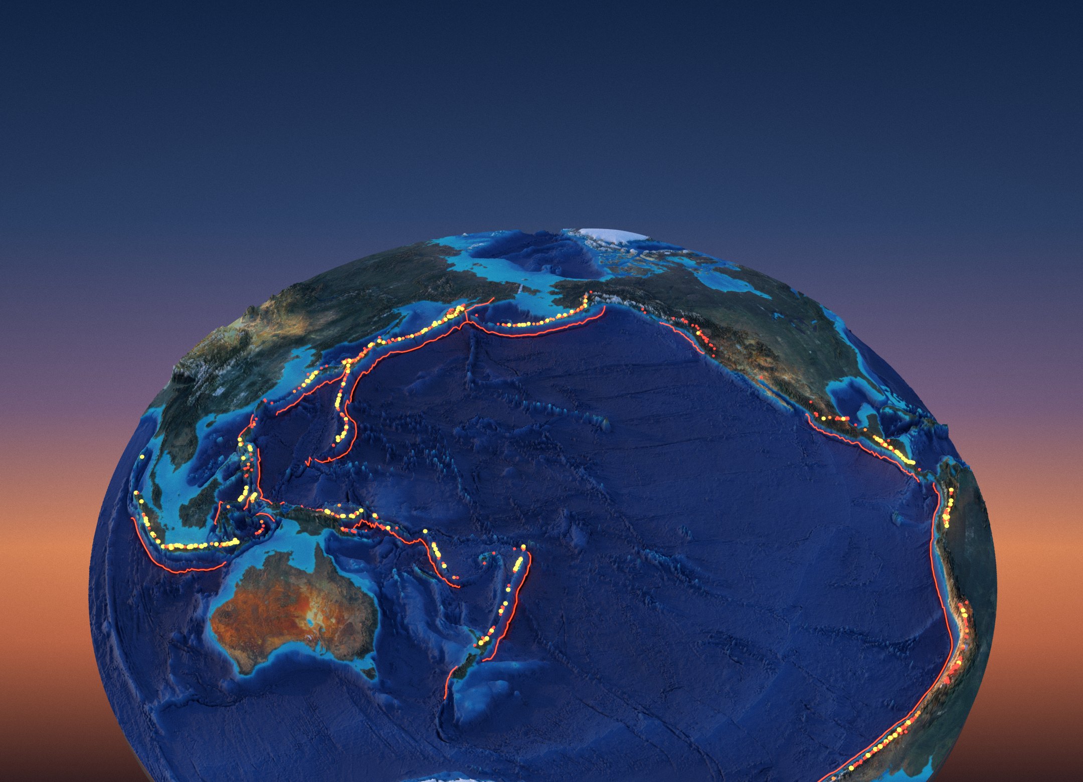
Spin the ring
793 volcanoes on one horseshoe
Drag the globe and tap any dot: every Holocene volcano on the ring, coloured by its last eruption, with the trenches where the ocean floor sinks.
Big eruptions since 1800
122 eruptions of VEI 4 or more
Each dot is one eruption on the ring, sized by its explosivity; red halos show its death toll where one is recorded.
Volcanic Explosivity Index
Each step is ten times bigger
Slide through the scale: the cubes show the volume of erupted rock and ash to scale, and the counts are the ring’s own eruptions.
The lineup, at true scale
From sea floor to 6,879 m
Real west–east profiles through 22 summits, drawn on top of each other with no vertical exaggeration; tap a name or a slope.
20 volcanoes in 3D
The ring’s landmark volcanoes
Each block is 20 × 20 km of real terrain and real satellite colour around the summit, all seen from the same camera; tap one to find it on the globe and in the lineup.
Every block is 20 × 20 km, seen by the same camera from the south-south-west, with heights exaggerated 1.5 times and the base cut 300 m below its lowest point; the scale bar is 5 km. Relief: Copernicus GLO-30; colour: Sentinel-2 cloudless 2016 (snow kept; small clouds filled from the ground around them); sea floor: ETOPO 2022, under a translucent sea. Ojos del Salado and Llullaillaco, the two tallest volcanoes on the ring, are not modelled because their 2016 imagery is largely cloud-covered; they appear in the lineup.
The human cost
The deadliest eruptions on the ring
Deaths recorded by NOAA’s Significant Volcanic Eruptions Database; the ring accounts for 260,213 of its 335,757 recorded volcano deaths (78%).
- Tambora 1815Indonesia · VEI 7
- Krakatau 1883Indonesia · VEI 6
- Ilopango 450El Salvador · VEI 6
- Nevado del Ruiz 1985Colombia · VEI 3
- Unzen 1792Japan · VEI 2
- Kelud 1586Indonesia · VEI 5
- Santa María 1902Guatemala · VEI 6
- Kelud 1919Indonesia · VEI 4
- Tungurahua 1640Ecuador · VEI 3
- Galunggung 1822Indonesia · VEI 5
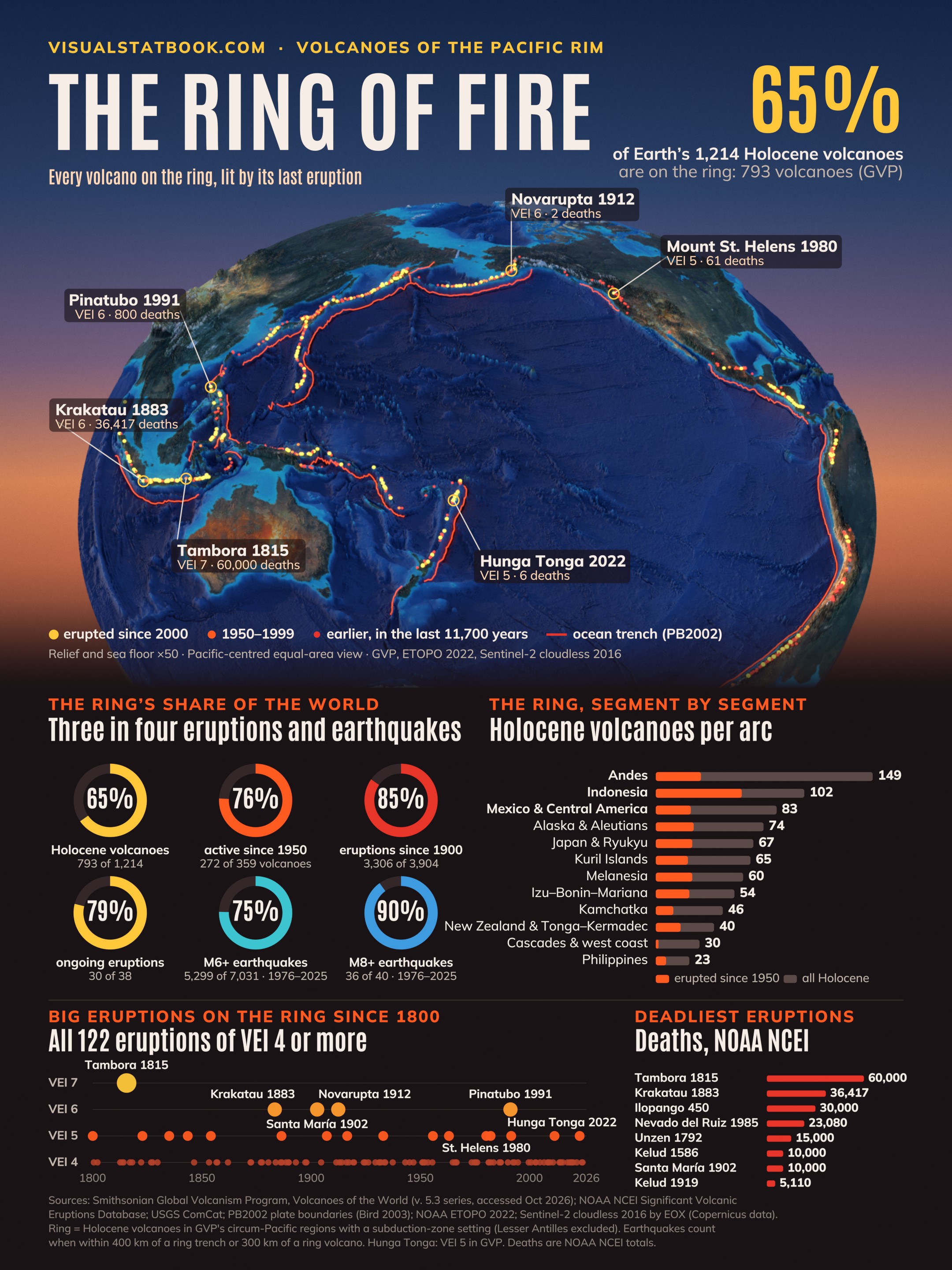
The poster
The whole ring on one page
The relief disc, the ring’s share of eruptions and earthquakes, every arc ranked and two centuries of big eruptions.
Open the full-size posterShow the full data table
| Volcano | Country | Elevation m | Type | Last eruption | Largest VEI | Eruptions since 1900 |
|---|---|---|---|---|---|---|
| El Misti | Peru | 5,793 | Stratovolcano | 1985 | 4 | 1 |
| Villarrica | Chile | 2,847 | Stratovolcano | 2025 | 5 | 41 |
| Cotopaxi | Ecuador | 5,911 | Stratovolcano | 2023 | 5 | 12 |
| Pico de Orizaba | Mexico | 5,564 | Stratovolcano | 1846 | 5 | 0 |
| Popocatépetl | Mexico | 5,393 | Stratovolcano | 2026 | 5 | 10 |
| Nevado del Ruiz | Colombia | 5,279 | Stratovolcano | 2026 | 4 | 5 |
| Klyuchevskoy | Russia | 4,754 | Stratovolcano | 2025 | 4 | 73 |
| Mount Rainier | United States | 4,392 | Stratovolcano | 1450 | 4 | 0 |
| Mount Fuji | Japan | 3,776 | Stratovolcano | 1708 | 5 | 0 |
| Santa María | Guatemala | 3,745 | Stratovolcano | 2026 | 6 | 3 |
| Tambora | Indonesia | 2,850 | Stratovolcano | 1967 | 7 | 1 |
| Merapi | Indonesia | 2,910 | Stratovolcano | 2026 | 4 | 31 |
| Mount St. Helens | United States | 2,549 | Stratovolcano | 2008 | 6 | 4 |
| Mayon | Philippines | 2,462 | Stratovolcano | 2026 | 4 | 30 |
| Sakurajima (Aira) | Japan | 1,117 | Caldera | 2026 | 6 | 12 |
| Pinatubo | Philippines | 1,486 | Stratovolcano | 2021 | 6 | 4 |
| Novarupta–Katmai | United States | 841 | Caldera | 1912 | 6 | 1 |
| Krakatau | Indonesia | 285 | Caldera | 2024 | 6 | 46 |
| Taal | Philippines | 311 | Caldera | 2026 | 6 | 16 |
| Hunga Tonga–Hunga Ha'apai | Tonga | 114 | Caldera | 2022 | 5 | 6 |
Ring of Fire = Holocene volcanoes in the Smithsonian GVP's eight circum-Pacific volcanic regions whose tectonic setting GVP gives as a subduction zone, excluding the Atlantic-facing Lesser Antilles arc. Hotspot, rift and intraplate volcanoes are not counted.
Elevations are the Smithsonian GVP summit heights; Ojos del Salado is given as 6,879 m by GVP (other sources give up to 6,893 m). VEI values are GVP's; NOAA NCEI lists the 2022 Hunga Tonga–Hunga Ha'apai eruption as VEI 6, GVP as VEI 5.
“Continuing” follows the Smithsonian eruption list (its latest eruption start is 29 Dec 2025); last-eruption years come from the Holocene volcano table (latest eruption start recorded: 2026-03-10).
Questions
Ring of Fire FAQ
What is the Ring of Fire?
The Ring of Fire is the horseshoe of volcanoes and earthquake zones around the Pacific Ocean, where ocean plates sink beneath their neighbours at deep trenches. On this page it means the 793 Holocene volcanoes that the Smithsonian Global Volcanism Program places in its circum-Pacific regions with a subduction-zone setting, from New Zealand and Indonesia through Japan, Kamchatka and Alaska to the Andes. That is 65% of the world's 1,214 Holocene volcanoes.
How many active volcanoes are on the Ring of Fire?
793 volcanoes have erupted in the last 11,700 years. Of those, 272 have erupted since 1950 (76% of the 359 worldwide) and 179 since 2000. 30 of the 38 eruptions that the Smithsonian lists as continuing are on the ring.
What share of earthquakes happen on the Ring of Fire?
Of the 7,031 magnitude 6+ earthquakes in the USGS catalogue from 1976 to 2025, 5,299 (75%) struck within 400 km of a Pacific-rim trench or 300 km of a ring volcano. The share rises with size: 79% of M7+ and 36 of 40 M8+ earthquakes, including the 2004 Sumatra and 2011 Tōhoku quakes.
What was the largest eruption on the Ring of Fire?
In recorded history, Tambora in Indonesia in April 1815 (VEI 7), which NOAA NCEI links to about 60,000 deaths. The largest of the 20th century was Novarupta in Alaska in 1912 (VEI 6), followed by Pinatubo in the Philippines in 1991 (VEI 6). Krakatau in 1883 (VEI 6) caused tsunamis that killed 36,417 people.
Which is the tallest volcano on the Ring of Fire?
Ojos del Salado on the Chile–Argentina border, 6,879 m in the Smithsonian database, is the highest volcano on Earth; Llullaillaco (6,739 m) is next. Both rise from the Andean plateau, so their height above the surrounding land is only 2–3 km, while Klyuchevskoy in Kamchatka rises about 4 km above its base.
Which Ring of Fire volcanoes are erupting now?
The Smithsonian eruption list flags 30 eruptions on the ring as continuing, among them Ambae, Bagana, Dukono, Fuego, Great Sitkin, Home Reef, Ibu, Kanlaon, Krasheninnikov, Langila, Lewotolok, Manam, Marapi, Masaya, Merapi, Nevado del Ruiz, Popocatépetl, Poás, Puracé, Reventador, Sabancaya, Sakurajima (Aira), Sangay, Santa María, Semeru, Sheveluch, Suwanosejima, Taal, Tofua and Yasur. Eruptions start and stop all the time, so check the Smithsonian's weekly reports for the latest.