


The depth lineup
Twenty real cross-sections under one sea-level line
Each shape is a west–east slice through the lowest point, cut from Copernicus elevation data; everything under the blue line lies below the sea.
Let the sea in
Open a channel and watch the depression fill
Pick a depression and raise the water: at 0 m it fills to sea level, the area a breach to the ocean would drown.
Fifty years of measurements
The lowest shore on Earth keeps sinking
Drag along the line: the Israel Water Authority has gauged the Dead Sea since 1976, and every year its shore is about a metre lower.
Every country's lowest point
Thirty-five countries and territories dip below the sea
Tap any country for its lowest point from the CIA World Factbook; most coastal nations bottom out at the sea itself.
Real relief
All twenty, modelled from satellite elevation
Each block is real Copernicus terrain draped with Sentinel-2 colour, cut by a teal sheet at sea level; tap one to select it across the page.
Same camera for every block; heights are exaggerated by the factor on each card, and scale bars give distance at the block centre. A small flag stands at each lowest point.
The poster
Below sea level, on one page
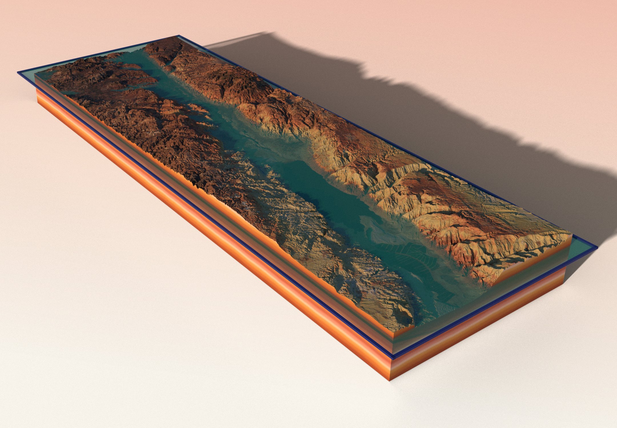
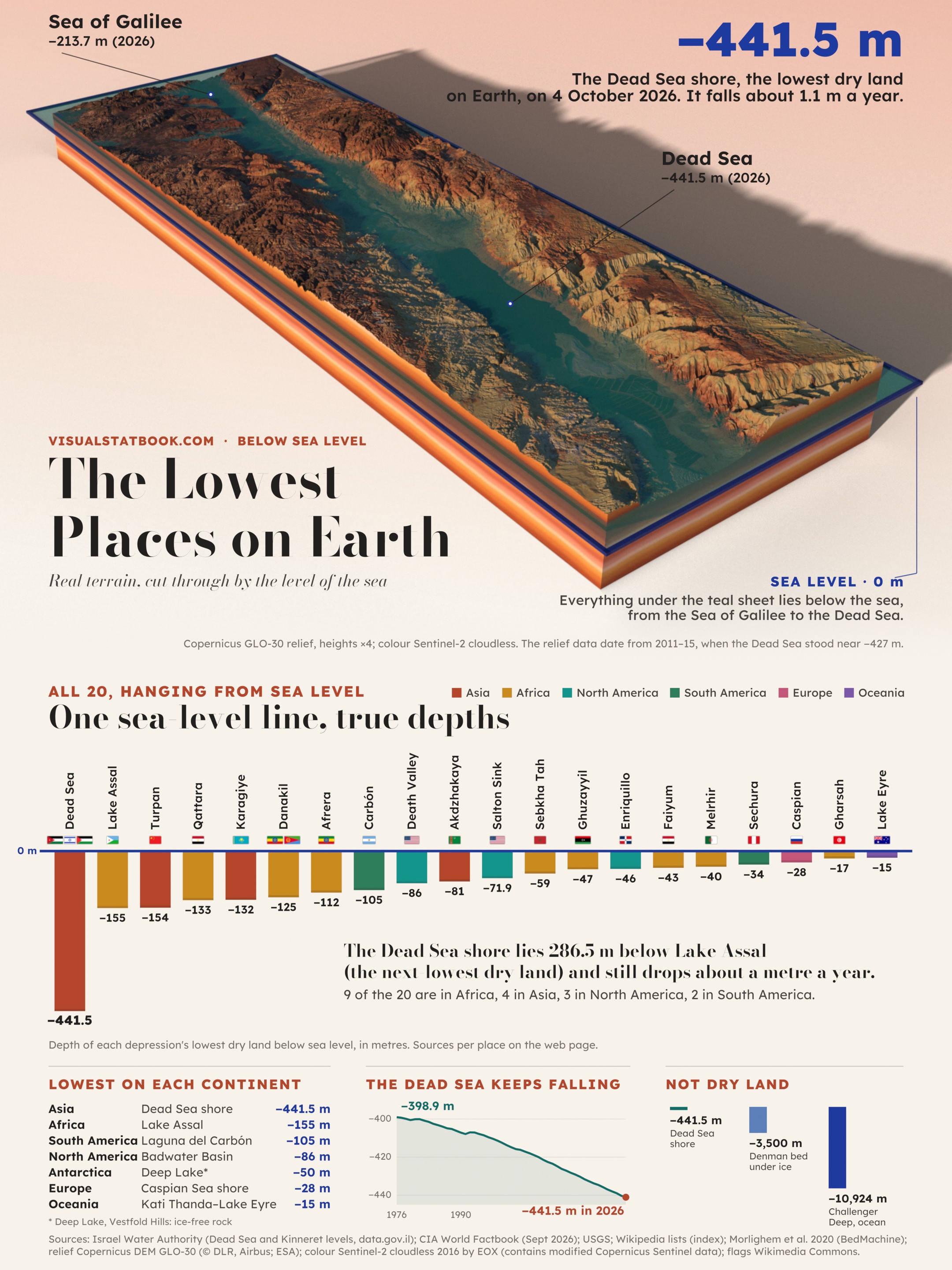
The rift model, the 20-depression lineup with flags, the continent lows and fifty years of the Dead Sea on a 2160 × 2880 poster.
Open the full-size posterShow the full data table
| # | Depression | Countries | Continent | Lowest point | GLO-30 check | Below 0 m, km² | Source |
|---|---|---|---|---|---|---|---|
| 1 | Dead Sea (Jordan Rift) | Jordan, Israel, Palestine (West Bank) | Asia | −441.5 m | −427 m | 1,970+ | Israel Water Authority, Dead Sea level on 04 Oct 2026 |
| 2 | Lake Assal | Djibouti | Africa | −155 m | −154.3 m | 250 | CIA World Factbook (Djibouti) |
| 3 | Turpan Depression (Ayding Lake) | China | Asia | −154 m | −154.9 m | 3,290+ | CIA World Factbook (China) |
| 4 | Qattara Depression | Egypt | Africa | −133 m | −135.1 m | 19,680+ | CIA World Factbook (Egypt) |
| 5 | Karagiye Depression | Kazakhstan | Asia | −132 m | −132 m | 1,430+ | CIA World Factbook (Kazakhstan, Qauyndy Oyysy) |
| 6 | Danakil Depression | Ethiopia, Eritrea | Africa | −125 m | −126.9 m | 3,810+ | CIA World Factbook (Ethiopia) |
| 7 | Lake Afrera | Ethiopia | Africa | −112 m | −115.4 m | 1,180+ | Wikipedia (Lake Afrera), index |
| 8 | Laguna del Carbón | Argentina | South America | −105 m | −109.5 m | 548 | CIA World Factbook (Argentina) |
| 9 | Death Valley (Badwater Basin) | United States | North America | −86 m | −87.1 m | 768+ | USGS, Highest and lowest elevations (−282 ft) |
| 10 | Akdzhakaya Depression | Turkmenistan | Asia | −81 m | −75.3 m | 65 | Wikipedia list of elevation extremes, index |
| 11 | Salton Sink (Salton Sea) | United States | North America | −71.9 m | −72.5 m | 3,000+ | Wikipedia (Salton Sea surface), index |
| 12 | Sebkha Tah | Morocco | Africa | −59 m | −59 m | 363 | CIA World Factbook (Morocco) |
| 13 | Sabkhat Ghuzayyil | Libya | Africa | −47 m | −49.1 m | 1,170+ | CIA World Factbook (Libya) |
| 14 | Lake Enriquillo | Dominican Republic | North America | −46 m | −38 m | 596 | CIA World Factbook (Dominican Republic) |
| 15 | Faiyum Depression (Lake Qarun) | Egypt | Africa | −43 m | −48.4 m | 908+ | Wikipedia list of places below sea level, index |
| 16 | Chott Melrhir | Algeria | Africa | −40 m | −35.3 m | 6,970+ | CIA World Factbook (Algeria) |
| 17 | Sechura Depression | Peru | South America | −34 m | −45 m | 178 | Wikipedia list of elevation extremes (Peru), index |
| 18 | Caspian shore (Dagestan) | Russia | Europe | −28 m | −29 m | — | CIA World Factbook (Russia, Azerbaijan, Iran) |
| 19 | Shatt al Gharsah | Tunisia | Africa | −17 m | −22 m | 1,160+ | CIA World Factbook (Tunisia) |
| 20 | Kati Thanda–Lake Eyre | Australia | Oceania | −15 m | −15.5 m | 13,210+ | CIA World Factbook (Australia) |
Lowest dry land: the lowest exposed ground, which for a terminal lake is its shore at the water level. Lake and sea floors, ice-covered bedrock and human-made pits (mines, tunnels) are not counted in the ranking.
Lowest point: the published figure (source column). GLO-30 check: the lowest Copernicus DEM value in the model after a 150 m median filter; the DEM is a 2011–15 radar surface model, so lake surfaces show their level at that time and salt flats can read a few metres low.
Below 0 m: the area under sea level connected to the lowest point inside the modelled block, lake surfaces included; a plus sign means the low ground runs on beyond the block. Not given for the Caspian, where the block holds the sea itself.
Questions
Below sea level FAQ
What is the lowest point on land on Earth?
The shore of the Dead Sea, on the border of Jordan, Israel and the West Bank. Its level was −441.5 m on 4 October 2026 (Israel Water Authority), 286.5 m lower than Lake Assal in Djibouti (−155 m), the next-lowest dry land.
Why does the Dead Sea keep getting lower?
More water evaporates than flows in, since most of the Jordan River is diverted and mineral works evaporate brine. The level fell from −398.9 m in October 1976 to −441.5 m in October 2026, about 1.1 m a year over the last decade.
What is the lowest point in Africa, the Americas, Europe and Australia?
Africa: Lake Assal, Djibouti (−155 m). South America: Laguna del Carbón, Argentina (−105 m). North America: Badwater Basin in Death Valley (−86 m, USGS). Europe: the Caspian Sea shore (−28 m). Oceania: Kati Thanda–Lake Eyre (−15 m).
Is Death Valley the lowest point on Earth?
No. Badwater Basin (−86 m) is the lowest point in North America, but 8 of the depressions on this page are lower, led by the Dead Sea, Lake Assal and the Turpan Depression in China (−154 m).
What about places under ice or water?
They are not dry land, so they are left out of the ranking. Bedrock under the Denman Glacier in Antarctica lies more than 3,500 m below sea level (BedMachine Antarctica), and the ocean floor reaches −10,924 m in the Challenger Deep. Antarctica's lowest ice-free ground is Deep Lake at about −50 m.
How many countries have land below sea level?
35 countries and territories have a lowest point below sea level in the CIA World Factbook (September 2026), from Jordan, Israel and the West Bank at the Dead Sea to the Netherlands (−7 m) and Suriname (−2 m). Most others reach their lowest point at the sea.