


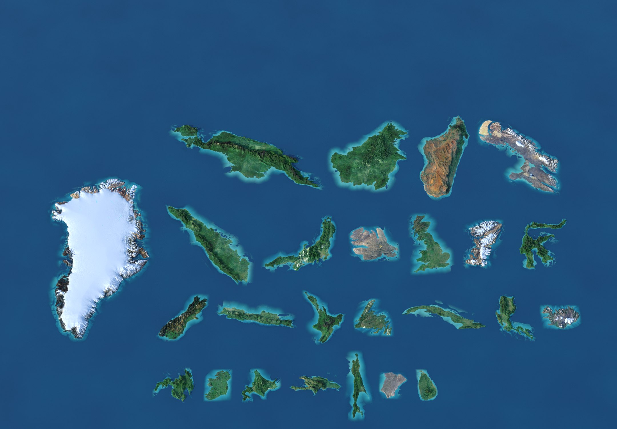
Area, people, peaks
Big is not the same as busy
Switch the measure and the 25 islands re-sort: Greenland leads by area, Java by people, New Guinea by height.
Where they are
From the Arctic to the tropics
Spin the globe or pick an island: nine of the 25 lie in the Arctic and the North Atlantic, seven in the warm seas of Southeast Asia and New Guinea.
The poster
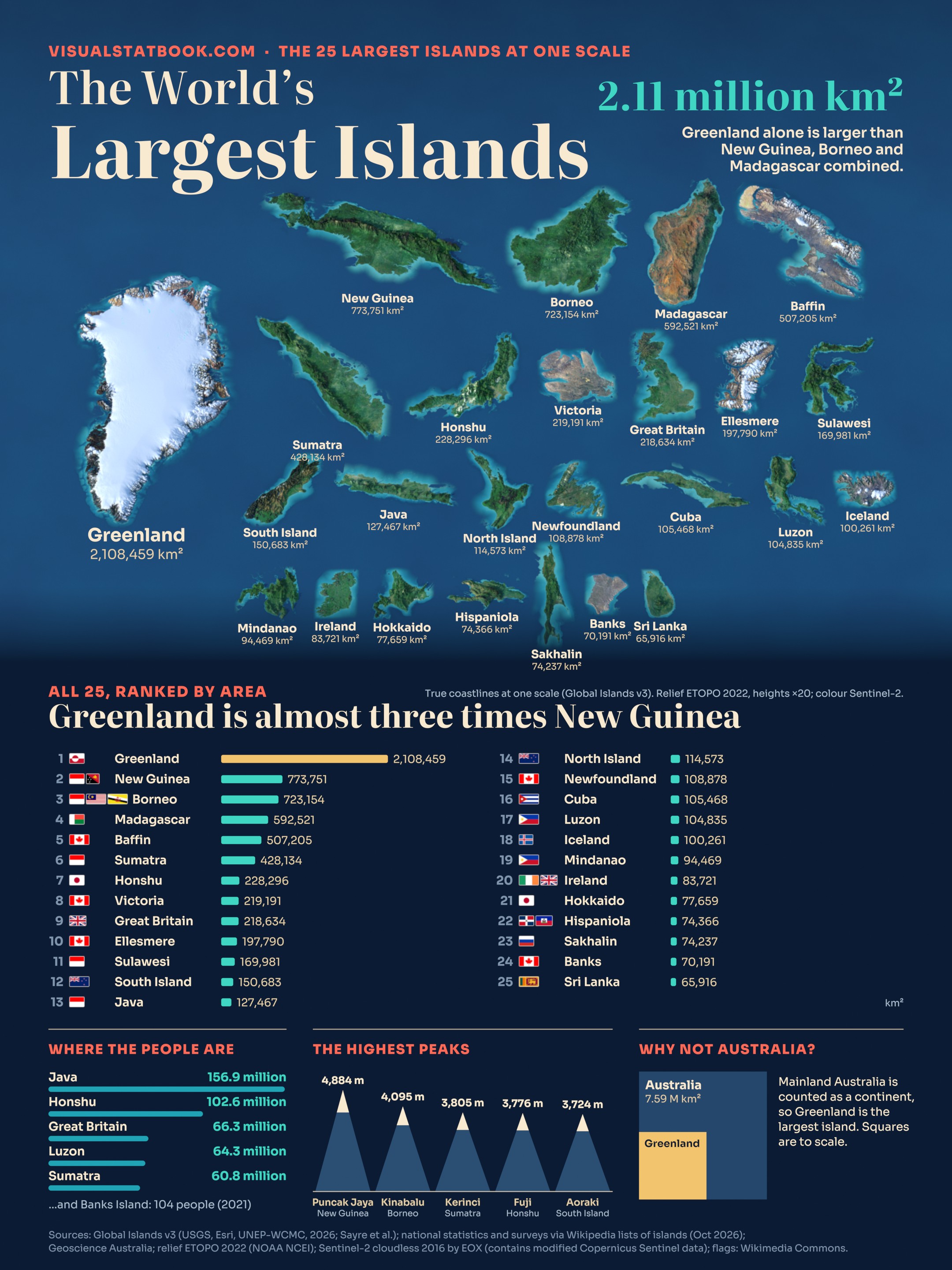
Twenty-five islands on one page
The same-scale models, the ranking with flags, the busiest islands and the highest peaks on a 2160 × 2880 poster.
Open the full-size posterShow the full data table
| # | Island | Countries | Area km² | Population | Highest point | m |
|---|---|---|---|---|---|---|
| 1 | Greenland | Greenland (Denmark) | 2,108,459 | 56,831 (2025) | Gunnbjørn Fjeld | 3,694 |
| 2 | New Guinea | Indonesia, Papua New Guinea | 773,751 | 14,800,000 (2020) | Puncak Jaya | 4,884 |
| 3 | Borneo | Indonesia, Malaysia, Brunei | 723,154 | 23,720,000 (2020) | Mount Kinabalu | 4,095 |
| 4 | Madagascar | Madagascar | 592,521 | 31,964,956 (2024) | Maromokotro | 2,876 |
| 5 | Baffin Island | Canada | 507,205 | 13,039 (2021) | Mount Odin | 2,147 |
| 6 | Sumatra | Indonesia | 428,134 | 60,795,669 (2023) | Mount Kerinci | 3,805 |
| 7 | Honshu | Japan | 228,296 | 102,572,815 (2020) | Mount Fuji | 3,776 |
| 8 | Victoria Island | Canada | 219,191 | 2,168 (2021) | unnamed hill | 655 |
| 9 | Great Britain | United Kingdom | 218,634 | 66,344,800 (2023) | Ben Nevis | 1,345 |
| 10 | Ellesmere Island | Canada | 197,790 | 144 (2021) | Barbeau Peak | 2,616 |
| 11 | Sulawesi | Indonesia | 169,981 | 20,568,411 (2023) | Latimojong (Rantemario) | 3,478 |
| 12 | South Island | New Zealand | 150,683 | 1,256,700 (2025) | Aoraki / Mount Cook | 3,724 |
| 13 | Java | Indonesia | 127,467 | 156,927,804 (2024) | Semeru | 3,676 |
| 14 | North Island | New Zealand | 114,573 | 4,067,400 (2025) | Mount Ruapehu | 2,797 |
| 15 | Newfoundland | Canada | 108,878 | 477,787 (2016) | The Cabox | 814 |
| 16 | Cuba | Cuba | 105,468 | 10,055,968 (2023) | Pico Turquino | 1,974 |
| 17 | Luzon | Philippines | 104,835 | 64,301,558 (2024) | Mount Pulag | 2,928 |
| 18 | Iceland | Iceland | 100,261 | 394,324 (2026) | Hvannadalshnúkur | 2,110 |
| 19 | Mindanao | Philippines | 94,469 | 27,384,138 (2024) | Mount Apo | 2,954 |
| 20 | Ireland | Ireland, United Kingdom | 83,721 | 7,026,636 (2022) | Carrauntoohil | 1,039 |
| 21 | Hokkaido | Japan | 77,659 | 4,985,419 (2025) | Asahi-dake | 2,291 |
| 22 | Hispaniola | Dominican Republic, Haiti | 74,366 | 22,569,800 (2024) | Pico Duarte | 3,098 |
| 23 | Sakhalin | Russia | 74,237 | 489,638 (2019) | Mount Lopatin | 1,609 |
| 24 | Banks Island | Canada | 70,191 | 104 (2021) | Durham Heights | 730 |
| 25 | Sri Lanka | Sri Lanka | 65,916 | 21,781,800 (2024) | Pidurutalagala | 2,524 |
Continental landmasses are not counted as islands: Afro-Eurasia, the Americas, Antarctica and mainland Australia (7,591,608 km², Geoscience Australia) are continents. Greenland is therefore the largest island.
Areas come from one global 30 m satellite shoreline (Landsat 2015), so every island is measured the same way. National figures can differ by several per cent, mostly where the coastline is drawn across estuaries, tidal flats and mangroves (Great Britain: 209,331 km² by the Ordnance Survey; Sumatra and Sulawesi were long quoted 6 to 11% larger).
With these figures Cuba (105,468 km²) ranks just above Luzon (104,835 km²) and Hispaniola (74,366 km²) just above Sakhalin (74,237 km²); with the dataset's geodesic areas Sakhalin is ahead of Hispaniola. Both pairs swap places between sources.
Populations are the latest national census or estimate available for each island; years differ (2016 to 2026), and Madagascar, Cuba, Iceland, Sri Lanka, Greenland and Hokkaido are given for the whole country, territory or prefecture, including small offshore islands.
Greenland's area includes its ice sheet; ETOPO 2022's bedrock layer puts about four-fifths of the island under ice.
Questions
Islands FAQ
What is the largest island in the world?
Greenland, at 2,108,459 km² (Global Islands v3). It is about 2.7 times the size of New Guinea, the second largest, and larger than New Guinea, Borneo and Madagascar combined (2,089,426 km²). Most of it lies under an ice sheet more than 3,000 m high.
Why is Australia not counted as the largest island?
By convention Australia is a continent, not an island. Mainland Australia covers about 7,591,608 km² (Geoscience Australia), more than three times Greenland, and geographers treat the four continental landmasses (Afro-Eurasia, the Americas, Antarctica and Australia) separately from islands.
Which islands are shared by more than one country?
Borneo is shared by Indonesia, Malaysia and Brunei; New Guinea by Indonesia and Papua New Guinea; Hispaniola by the Dominican Republic and Haiti; and Ireland by Ireland and the United Kingdom (Northern Ireland). Greenland is a self-governing part of the Kingdom of Denmark.
Which of the largest islands has the most people?
Java, with about 156.9 million people (2024), the most of any island on Earth, at 1,231 people per km². Honshu (102.6 million) and Great Britain (66.3 million) follow. At the other end, Banks Island has 104 residents and Ellesmere Island 144.
What is the highest mountain on an island?
Puncak Jaya on New Guinea, 4,884 m. Mount Kinabalu on Borneo (4,095 m), Mount Kerinci on Sumatra (3,805 m) and Mount Fuji on Honshu (3,776 m) come next among the 25 largest islands.
Why do island areas differ between sources?
Areas depend on where the coastline is drawn across tidal flats, estuaries and mangroves, and on the map's resolution. This page uses one global 30 m satellite shoreline for all islands. National figures can differ by several per cent: the Ordnance Survey gives Great Britain 209,331 km², against 218,634 km² here.