


The dive
Sink to the bottom of the world
Scroll to descend 10,935 metres. Every trench floor, ocean zone and landmark passes at its real depth.
To scale
Fifteen trenches, one cross-section
Real seafloor profiles cut straight across each trench at its deepest point, all on one scale. Pick a trench, then stand Everest on its floor.
Where plates dive
A ring of trenches around the Pacific
Trenches mark subduction zones, where one plate slides beneath another. Drag the globe, or tap a trench to fly there.
3D models
Every trench, cut open
Each block is real GEBCO 2025 seafloor, sliced across the trench at its deepest point with the subducting plate on the left. Tap a model to select that trench everywhere on the page.
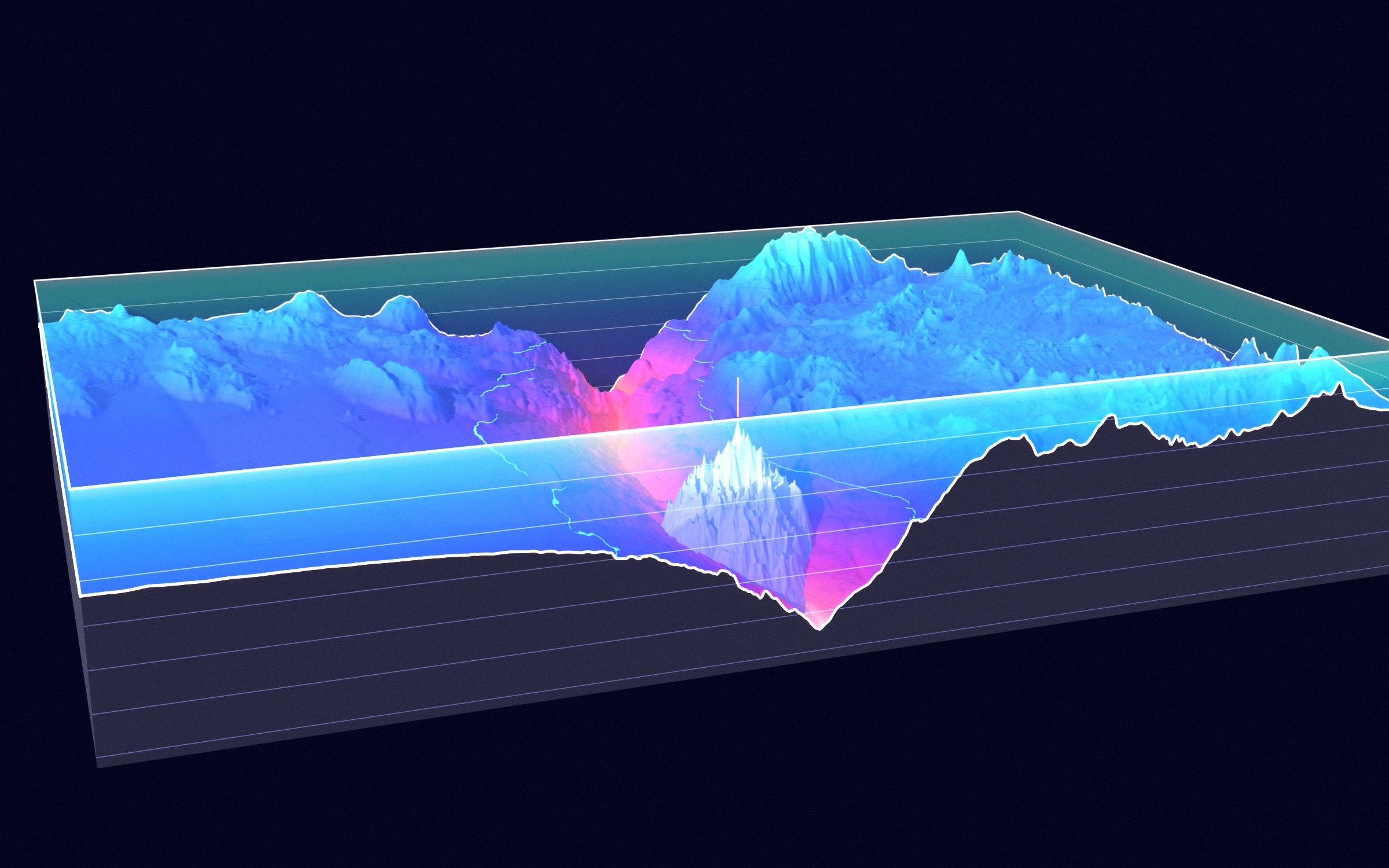
All 15 blocks share one camera and one scale: 320 km across the trench and 150 km along it, heights ×6, base 12.5 km below sea level, lines every 2,000 m of depth on the cut faces, and the coral bar in front is 100 km long. The seafloor is coloured by depth, with the hadal zone (below 6,000 m) glowing from violet to coral and its 6,000 m contour traced in green.
The poster
The abyss on one page
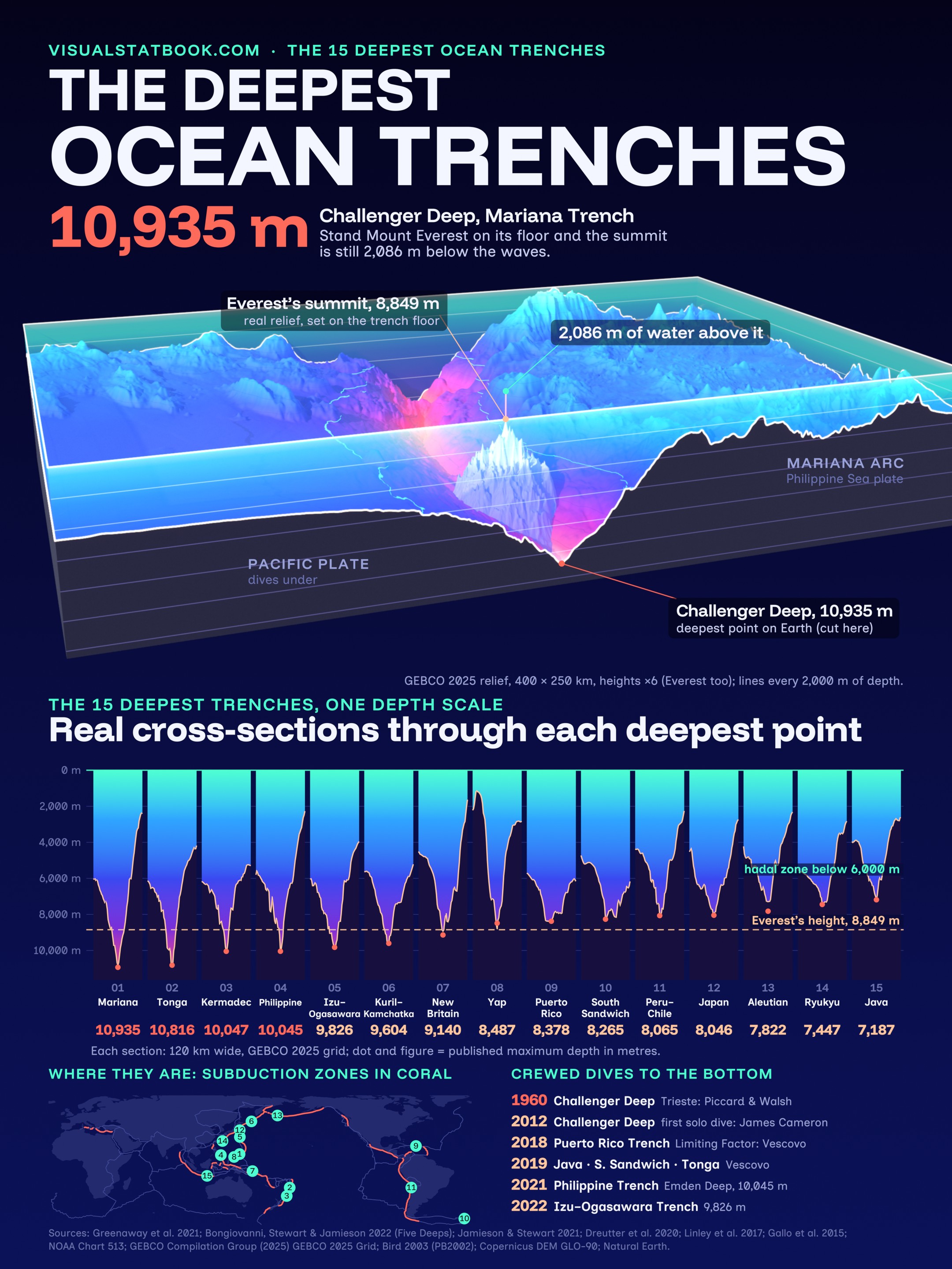
The Everest comparison, all 15 cross-sections and the map of subduction zones on a 2160 × 2880 poster.
Open the full-size posterShow the full data table
| # | Trench | Deepest point | Ocean | Max depth m | Source | GEBCO grid m | Plates | Length km |
|---|---|---|---|---|---|---|---|---|
| 1 | Mariana Trench | Challenger Deep | Pacific | 10,935 ± 6 | Greenaway et al. 2021 | 10,920 | Pacific under Philippine Sea | 2,550 |
| 2 | Tonga Trench | Horizon Deep | Pacific | 10,816 ± 16 | Five Deeps survey (Bongiovanni et al. 2022) | 10,813 | Pacific under Tonga | 1,375 |
| 3 | Kermadec Trench | Scholl Deep | Pacific | 10,047 | Linley et al. 2017 | 10,044 | Pacific under Kermadec | 1,000 |
| 4 | Philippine Trench | Emden Deep | Pacific | 10,045 | Caladan Oceanic dive 2021 | 10,023 | Philippine Sea under Sunda | 1,320 |
| 5 | Izu–Ogasawara Trench | – | Pacific | 9,826 ± 11 | Caladan Oceanic dive 2022 | 9,841 | Pacific under Philippine Sea | 1,122 |
| 6 | Kuril–Kamchatka Trench | – | Pacific | 9,604 | Dreutter et al. 2020 | 9,595 | Pacific under Okhotsk | 2,089 |
| 7 | New Britain Trench | Planet Deep | Pacific (Solomon Sea) | 9,140 | Gallo et al. 2015 | 8,949 | Solomon Sea under South Bismarck | 840 |
| 8 | Yap Trench | – | Pacific | 8,487 | Jamieson & Stewart 2021 (GMRT) | 8,818 | Caroline under Philippine Sea | 720 |
| 9 | Puerto Rico Trench | Brownson Deep | Atlantic | 8,378 ± 5 | Five Deeps survey (Bongiovanni et al. 2022) | 8,392 | North American under Caribbean | 810 |
| 10 | South Sandwich Trench | Meteor Deep | Atlantic / Southern | 8,265 ± 13 | Five Deeps survey (Bongiovanni et al. 2022) | 8,261 | South American under South Sandwich | 965 |
| 11 | Peru–Chile (Atacama) Trench | Richards Deep | Pacific | 8,065 | Encyclopaedia Britannica | 7,998 | Nazca under South American | 5,900 |
| 12 | Japan Trench | – | Pacific | 8,046 | Jamieson & Stewart 2021 (GMRT) | 8,034 | Pacific under Okhotsk | 800 |
| 13 | Aleutian Trench | – | Pacific | 7,822 | NOAA Chart 513 | 7,291 | Pacific under North American | 3,400 |
| 14 | Ryukyu Trench | – | Pacific | 7,447 | Jamieson & Stewart 2021 (GMRT) | 7,436 | Philippine Sea under Okinawa | 1,012 |
| 15 | Java (Sunda) Trench | – | Indian | 7,187 ± 13 | Five Deeps survey (Bongiovanni et al. 2022) | 7,184 | Australian under Sunda | 3,200 |
Max depth: best published figure, preferring calibrated multibeam surveys and submersible pressure readings (± is the stated uncertainty). GEBCO grid: the deepest cell of the GEBCO 2025 15-arc-second grid within 40 km of the published point; the grid smooths narrow deeps and can hold spurious soundings, so it can be shallower (Aleutian: about 7,300 m against a 7,822 m chart sounding) or deeper (Yap: 8,818 m against 8,487 m) than the published value.
Plates follow Bird’s PB2002 model at the deepest point (subducting plate first). The Mariana Trench’s deepest part lies where PB2002 places the Pacific plate under the Philippine Sea plate; the Mariana microplate begins further north. PB2002 classes the Puerto Rico Trench as an oblique transform and the Yap Trench as a convergent boundary without polarity.
Lengths are commonly quoted figures and use different definitions (whole trench, or the part deeper than 6,000 m in Jamieson & Stewart 2021). Kermadec (10,047 m) and Philippine (10,045 m) are effectively tied; older figures of 10,540 m for the Philippine Trench and 10,500 m for the Kuril–Kamchatka Trench were not confirmed by modern surveys.
Questions
Ocean trenches FAQ
What is the deepest ocean trench?
The Mariana Trench in the western Pacific. Its deepest point, Challenger Deep, is 10,935 ± 6 m deep according to pressure-referenced submersible transects (Greenaway et al. 2021); the Five Deeps Expedition measured 10,924 ± 15 m by multibeam sonar and 10,925 ± 4 m by submersible in 2019.
How does the Mariana Trench compare with Mount Everest?
Everest is 8,849 m high. Stood on the floor of Challenger Deep, its summit would still be 2,086 m below the sea surface. 7 of the 15 trenches are deeper than Everest is tall: Mariana, Tonga, Kermadec, Philippine, Izu–Ogasawara, Kuril–Kamchatka, New Britain.
What is the deepest point in each ocean?
Pacific: Challenger Deep, Mariana Trench (10,935 m). Atlantic: Brownson Deep, Puerto Rico Trench (8,378 ± 5 m). Indian: an unnamed deep in the Java Trench (7,187 ± 13 m). Southern: the part of the South Sandwich Trench south of 60° S (7,432 ± 13 m); the trench’s overall deepest point, Meteor Deep (8,265 m), lies in the Atlantic (Bongiovanni et al. 2022).
How do ocean trenches form?
Trenches form at subduction zones, where an older, denser oceanic plate bends and sinks beneath another plate. The deepest trenches are in the western Pacific, where the very old Pacific plate dives under the Philippine Sea, Tonga, Kermadec and Okhotsk plates; younger, lighter plates make shallower trenches, such as the Peru–Chile Trench (8,065 m) where the Nazca plate sinks under South America.
Has anyone been to the bottom of the deepest trenches?
Yes. Jacques Piccard and Don Walsh reached Challenger Deep in the bathyscaphe Trieste on 23 January 1960, and James Cameron dived there alone in 2012. Victor Vescovo’s submersible Limiting Factor made the first crewed dives to the Puerto Rico (2018), Java, South Sandwich and Tonga trenches (2019), to Emden Deep in the Philippine Trench (2021) and, in 2022, to the bottom of the Izu–Ogasawara Trench.
Why do published trench depths differ?
Echo-sounder depths depend on the speed of sound through the whole water column, which changes with temperature, salinity and pressure; older soundings could be hundreds of metres off. Modern surveys correct for this with measured profiles and check against pressure sensors, which is why figures such as 11,034 m for Challenger Deep or 10,540 m for the Philippine Trench have been revised down.