


01Dive
How deep can you go?
Every column is one lake’s water, hanging from its surface to scale. Drag the plumb bob, tap the chart or use the arrow keys; the map below follows your depth.
Where they areCircle size and colour: maximum depth. Tap a lake to dive to it.
02Slice Baikal
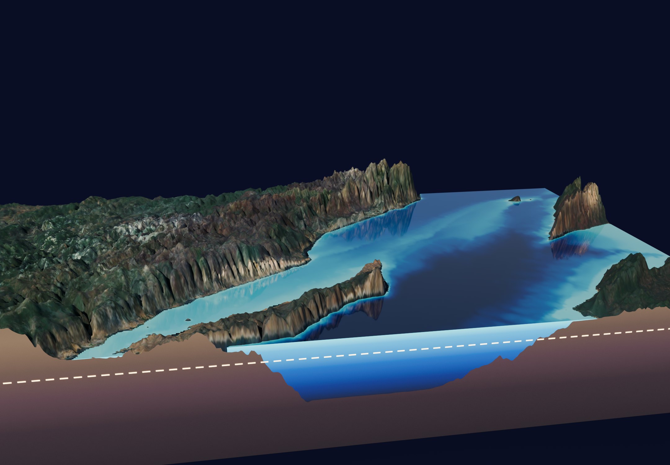
Cut the deepest lake open
A 3D block of the Baikal rift from NOAA’s ETOPO 2022 relief, with real lake-floor depths. Slide the cut along the lake (or drag the line on the map) and orbit the block to look inside.
Baikal rift in 3DDrag to orbit · pinch or scroll to zoom
03Cutaways
All 20, cut open
Each lake sliced through its deepest point, or through its centre where no survey grid maps the floor, with real relief and satellite colour. Depth is drawn to one scale on every model, so the probes compare directly; tap a model to dive to it.
- Probe to the published maximum depth
- Water down to a surveyed floor
- Sea level
Surveyed floor: Lake Baikal and the Caspian Sea, the only two of the 20 whose beds are mapped in the NOAA ETOPO 2022 and GEBCO 2025 grids. Maximum depth only: the other 18 (Lake Tanganyika, O’Higgins / San Martín, Viedma Lake, Lake Argentino, Lake Malawi, Issyk-Kul, Great Slave Lake, Crater Lake, Lake Matano, General Carrera, Hornindalsvatnet, Quesnel Lake, Sarez Lake, Lake Toba, Lake Tahoe, Salvatnet, Lake Kivu, Nahuel Huapi). Those grids hold just a flat water surface there, so the section is left as rock and the probe, at the lake centre (Lake Argentino: near the end of the Upsala arm, where its deepest sounding was taken), reaches the published maximum depth, not a mapped floor. Scale: depth is drawn to one vertical scale on all 20 models (1 km of depth = 14% of a block’s width), so the 500 m bar is the same on every card, and each block reaches 1.9 km below its lake’s surface. Widths differ, so each card has its own scale bar along the cut, and its heights are stretched relative to width by the factor shown (×1.1 for Salvatnet to ×72 for the Caspian Sea); where that factor is large the land relief is lightly smoothed. Relief: Copernicus DEM GLO-30/GLO-90 and NOAA ETOPO 2022; colour: Sentinel-2 cloudless 2016 by EOX.
04Sea level
Where the bottom is
Each bar runs from a lake’s surface down to its floor, measured against sea level. 12 of the 20 floors lie below the sea.
05Number one
Baikal in numbers
The deepest lake is also the oldest and holds the most fresh water.
23,615 km3
More water than all five Great Lakes
~20%
Of the world’s unfrozen surface fresh water (UNESCO)
25–30 M yrs
The oldest lake on Earth
−1,187 m
The deepest continental depression
How deep is 1,642 metres?
Not ranked: Lake Vostok
06Poster
The deep, on one page
The Baikal cutaway, the deepest 16 lakes to scale, floors against sea level and Baikal’s key numbers, on a 2160 × 2880 poster.
Open the full-size poster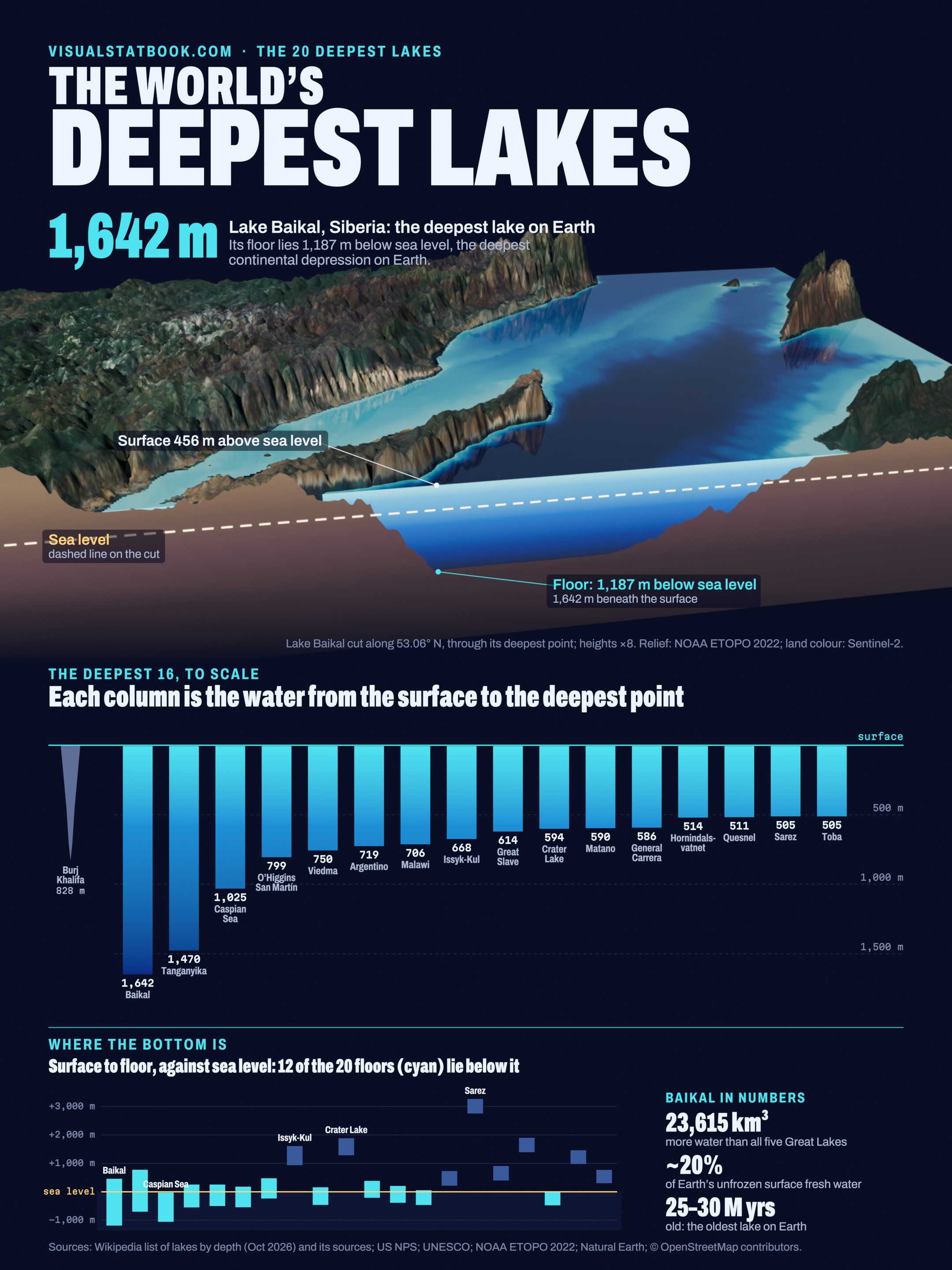
07Data
The 20 deepest lakes
Show the full data table
| # | Lake | Countries | Max depth (m) | Mean depth (m) | Surface (m) | Floor (m) | Volume (km³) | Origin |
|---|---|---|---|---|---|---|---|---|
| 1 | Lake Baikal | Russia | 1,642 | 744 | 455.5 | −1,186.5 | 23,615 | Rift |
| 2 | Lake Tanganyika | Tanzania, DR Congo, Burundi, Zambia | 1,470 | 570 | 773 | −697 | 18,750 | Rift |
| 3 | Caspian Sea | Kazakhstan, Turkmenistan, Azerbaijan, Russia, Iran | 1,025 | 211 | −28 | −1,053 | 78,200 | Tectonic (landlocked remnant of the Paratethys sea) |
| 4 | O'Higgins / San Martín Lake | Chile, Argentina | 799 | — | 252 | −547 | 68.9 | Glacial |
| 5 | Viedma Lake | Argentina | 750 | 100 | 252 | −498 | 119 | Glacial |
| 6 | Lake Argentino | Argentina | 719 | 155 | 178 | −541 | 220 | Glacial |
| 7 | Lake Malawi (Nyasa) | Malawi, Mozambique, Tanzania | 706 | 292 | 474 | −232 | 8,640 | Rift |
| 8 | Issyk-Kul | Kyrgyzstan | 668 | 278 | 1,607 | 939 | 1,736 | Tectonic |
| 9 | Great Slave Lake | Canada | 614 | 41 | 156 | −458 | 1,115 | Glacial |
| 10 | Crater Lake | USA | 594 | 350 | 1,883 | 1,289 | 18.7 | Volcanic/caldera |
| 11 | Lake Matano | Indonesia | 590 | — | 382 | −208 | — | Tectonic (graben) |
| 12 | General Carrera / Buenos Aires Lake | Chile, Argentina | 586 | — | 203 | −383 | — | Glacial (in a tectonic graben) |
| 13 | Hornindalsvatnet | Norway | 514 | 238 | 53 | −461 | 12.1 | Glacial |
| 14 | Quesnel Lake | Canada | 511 | 157 | 728 | 217 | 41.8 | Glacial (fjord lake) |
| 15= | Sarez Lake | Tajikistan | 505 | 202 | 3,263 | 2,758 | 16.1 | Landslide-dammed |
| 15= | Lake Toba | Indonesia | 505 | — | 905 | 400 | 244 | Volcanic/caldera |
| 17 | Lake Tahoe | USA | 501 | 305 | 1,897 | 1,396 | 150 | Tectonic (fault-block) |
| 18 | Salvatnet | Norway | 482 | 155 | 9 | −473 | 7 | Glacial |
| 19 | Lake Kivu | DR Congo, Rwanda | 480 | 240 | 1,460 | 980 | 550 | Rift (volcanically dammed) |
| 20 | Nahuel Huapi Lake | Argentina | 464 | 157 | 769 | 305 | 83.3 | Glacial (moraine-dammed glacial valleys) |
- Tie at 15: Sarez Lake and Lake Toba are both 505 m deep and share rank 15; rank 16 is skipped.
- Patagonia: the depths of O’Higgins / San Martín (799 m), Viedma (~750 m) and Argentino (719 m) each rest on a single recent survey. The US National Park Service list of 2017 still gave O’Higgins 836 m.
- Lake Kivu: 480 m on Wikipedia’s list; the Eawag institute gives 485 m, which would place Kivu above Salvatnet.
- Crater Lake: 594 m on Wikipedia’s list; the National Park Service gives 592 m from its 2000 multibeam survey.
- Lake Baikal: 1,642 m from the INTAS bathymetric map; the older NPS figure is 1,637 m. The 3D block uses the ETOPO 2022 grid, averaged to ~1.8 km cells, so its depths along a cut read slightly shallower.
- Caspian Sea: included as on Wikipedia’s list. Geologically it is a landlocked remnant of an ancient sea on oceanic crust, and its level is falling.
08Questions
Deep lakes FAQ
What is the deepest lake in the world?
Lake Baikal in Siberia, Russia, with a maximum depth of 1,642 m (INTAS bathymetric map; an older National Park Service figure is 1,637 m). Its surface is about 455.5 m above sea level, so its floor lies about 1,187 m below sea level: the deepest continental depression on Earth.
How much water does Lake Baikal hold?
About 23,615 km³, more than all five North American Great Lakes combined (about 22,700 km³). UNESCO puts that at about 20% of the world’s unfrozen surface fresh water.
What is the second-deepest lake?
Lake Tanganyika in East Africa, 1,470 m deep, shared by Tanzania, DR Congo, Burundi and Zambia. It is also the second-largest lake by volume (18,750 km³) and the longest freshwater lake.
What is the deepest lake in the Americas and in the United States?
O’Higgins / San Martín Lake on the Chile–Argentina border, 799 m deep according to a 2023 survey. In North America it is Great Slave Lake in Canada (614 m). In the United States it is Crater Lake, Oregon (594 m on Wikipedia’s list, 592 m by the National Park Service), followed by Lake Tahoe (501 m).
How many of the deepest lakes have floors below sea level?
12 of the 20. Even lakes whose surfaces sit hundreds of metres up, such as Baikal and Tanganyika, have floors below sea level. The Caspian Sea’s surface itself lies 28 m below sea level and its floor 1,053 m below.
Why is Lake Vostok not on the list?
Lake Vostok lies under about 4 km of Antarctic ice. It has no open surface, and its depth of roughly 900 m (estimates run from 510 to 900 m) comes from seismic and radar surveys, so it is left out of this ranking even though some lists place it fourth.